I'm coming home, here's the route if you're bored.
San Diego to Berkeley
| From: 526 Anderson Pl, San Diego, CA 92103 To: 1712 Ward St, Berkeley, CA 94703 |
| Driving Distance: 594.6 miles Time: 11 hours, 38 minutes |
 |
| Time | Distance | Instruction |
| 6:12 AM | 0.0 | 1 Depart 526 Anderson Pl, San Diego, CA 92103 on 5th Ave (North) for 0.3 mi |
| 6:13 AM | 0.3 | Turn RIGHT (East) onto University Ave for 87 yds |
| 6:13 AM | 0.3 | Turn LEFT (North) onto 6th Ave for 0.3 mi |
| 6:14 AM | 0.6 | Continue (North) on Ramp for 0.3 mi towards CA-163 |
| 6:15 AM | 0.9 | Merge onto SR-163 [Cabrillo Fwy] (North) for 7.8 mi |
| 6:24 AM | 8.7 | Turn off onto Ramp for 0.7 mi towards I-15 |
| 6:25 AM | 9.4 | Merge onto I-15 [Escondido Fwy] (North) for 31.0 mi |
| 6:53 AM | 40.4 | Turn off onto Ramp for 0.2 mi towards Old Highway 395 |
| 6:54 AM | 40.6 | Turn LEFT (North) onto US-395 [Old Highway 395] for 0.1 mi |
| 6:54 AM | 40.7 | 2 At I-15 & US-395, Escondido, CA 92026, return South on US-395 [Old Highway 395] for 120 yds |
| 6:54 AM | 40.8 | Continue (South) on Ramp for 0.2 mi towards I-15 |
| 6:54 AM | 41.0 | Merge onto I-15 [Escondido Fwy] (North) for 19.6 mi |
| 7:12 AM | 60.6 | Continue (North) on I-215 [Escondido Expy] for 25.3 mi towards I-215 / Riverside / San Bernardino |
| 7:36 AM | 85.9 | Turn off onto Ramp for 0.3 mi towards Van Buren Blvd |
| 7:37 AM | 86.1 | Turn RIGHT (East) onto Van Buren Blvd for 0.1 mi |
| 7:37 AM | 86.2 | Turn RIGHT (West) onto Local road(s) for 120 yds |
| 7:37 AM | 86.3 | 3 At I-215 & Van Buren Blvd, March Air Reserve Base, CA 92518, return East on Local road(s) for 120 yds |
| 7:38 AM | 86.4 | Turn LEFT (North) onto Van Buren Blvd for 0.1 mi |
| 7:38 AM | 86.5 | Turn RIGHT (North) onto Ramp for 0.2 mi towards I-215 / Riverside |
| 7:38 AM | 86.7 | Merge onto I-215 [Escondido Expy] (North) for 8.8 mi |
| 7:49 AM | 95.6 | Turn off onto Ramp for 0.4 mi towards CA-91 / I-215 / Riverside / Beach Cities / San Bernardino / Barstow |
| 7:49 AM | 96.0 | Merge onto I-215 [Riverside Fwy] (North) for 19.7 mi |
| 8:12 AM | 115.7 | 4 At I-215 I-15 Exit, turn off onto Ramp for 0.7 mi |
| 8:14 AM | 116.4 | Merge onto I-15 [Barstow Fwy] (North-West) for 6.5 mi |
| 8:20 AM | 122.9 | Turn off onto Ramp for 0.4 mi |
| 8:20 AM | 123.3 | Merge onto SR-138 (West) for 87 yds |
| 8:21 AM | 123.3 | Continue (West) on US-138 [SR-138] for 16.6 mi |
| 8:41 AM | 140.0 | Continue (West) on SR-138 [Antelope Hwy] for 25.1 mi |
| 9:12 AM | 165.1 | 5 At E Palmdale Blvd & 50th St E, Palmdale, CA 93552, stay on SR-138 [E Palmdale Blvd] (West) for 5.0 mi |
| 9:19 AM | 170.0 | Turn off onto Ramp for 0.3 mi towards CA-14 / CA-138 / Mojave |
| 9:20 AM | 170.3 | Merge onto SR-14 [SR-138] (North) for 29.6 mi |
| 9:21 AM | 171.6 | Refuel before here (last refuel was 171.6 miles ago) |
| 9:51 AM | 199.9 | At Antelope Valley Fwy SR-14 Exit, turn off onto Ramp for 0.1 mi |
| 9:51 AM | 200.0 | Merge onto SR-14 [Antelope Valley Fwy] (North) for 4.6 mi |
| 9:57 AM | 204.6 | Continue (North) on SR-58 [Sierra Hwy] for 4.2 mi |
| 10:02 AM | 208.8 | Turn off onto Ramp for 76 yds |
| 10:02 AM | 208.9 | Merge onto SR-58 [Sierra Hwy] (West) for 36.9 mi |
| 10:39 AM | 245.8 | Turn off onto Ramp for 0.2 mi |
| 10:39 AM | 246.0 | Turn LEFT (South) onto General Beale Rd for 87 yds |
| Construction in Bakersfield from 08/20/02 to 03/31/03 | ||
| 10:39 AM | 246.0 | 6 At SR-58 & General Beale Rd, Arvin, CA 93203, return North on General Beale Rd for 87 yds |
| Construction in Bakersfield from 08/20/02 to 03/31/03 | ||
| 10:39 AM | 246.1 | Turn LEFT (West) onto Ramp for 0.1 mi |
| Construction in Bakersfield from 08/20/02 to 03/31/03 | ||
| 10:39 AM | 246.2 | Merge onto SR-58 (West) for 16.9 mi |
| Construction in Bakersfield from 08/20/02 to 03/31/03 | ||
| 10:58 AM | 263.0 | Turn off onto Ramp for 0.6 mi |
| 10:59 AM | 263.6 | Merge onto SR-58 [SR-99] (North) for 1.6 mi |
| 11:02 AM | 265.3 | At SR-99 Pierce Rd Exit, turn off onto Ramp for 0.3 mi |
| 11:02 AM | 265.5 | Merge onto SR-58 [Rosedale Hwy] (West) for 5.8 mi |
| 11:12 AM | 271.3 | 7 At Rosedale Hwy & Allen Rd, Bakersfield, CA 93312, return North on SR-58 [Allen Rd] for 10 yds |
| 11:12 AM | 271.3 | Continue (North) on Allen Rd for 0.9 mi |
| 11:14 AM | 272.2 | Bear LEFT (North-West) onto Santa Fe Way for 4.3 mi |
| 11:22 AM | 276.6 | Bear LEFT (West) onto 7th Standard Rd for 43 yds |
| 11:23 AM | 276.6 | Bear RIGHT (North-West) onto Santa Fe Way for 2.8 mi |
| 11:28 AM | 279.4 | Continue (North-West) on Burbank St for 0.7 mi |
| 11:30 AM | 280.1 | Continue (North-West) on S Central Valley Hwy for 1.4 mi |
| 11:33 AM | 281.5 | Continue (North-West) on SR-43 [S Central Valley Hwy] for 0.8 mi |
| 11:35 AM | 282.3 | 8 At Lerdo Hwy & Santa Fe Way, Shafter, CA 93263, stay on SR-43 [Central Valley Hwy] (North-West) for 8.7 mi |
| 11:51 AM | 291.0 | Turn LEFT (West) onto SR-46 [Paso Robles Hwy] for 10.2 mi |
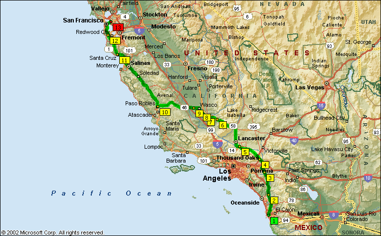
| 12:03 PM | 301.1 | 9 At SR-46 & Gun Club Rd, Wasco, CA 93280, stay on SR-46 [Paso Robles Hwy] (West) for 46.9 mi |
| Construction between Lost Hills and Buttonwillow from 08/05/02 to 02/24/03 | ||
| 12:59 PM | 348.0 | Continue (West) on SR-41 [SR-46] for 6.5 mi |
| 1:00 PM | 348.7 | Refuel before here (last refuel was 177.2 miles ago) |
| 1:07 PM | 354.5 | Bear RIGHT (West) onto SR-46 [E HWY-46] for 18.7 mi |
| 1:30 PM | 373.2 | 10 At SR-46 & N River Rd, Paso Robles, CA 93446, stay on SR-46 (West) for 0.1 mi |
| 1:30 PM | 373.3 | Turn off onto Ramp for 0.2 mi towards US-101 |
| 1:30 PM | 373.5 | Bear RIGHT (North) onto US-101 for 64.0 mi |
| 2:37 PM | 437.5 | Continue (North-West) on Ramp for 98 yds |
| 2:37 PM | 437.5 | Continue (North-West) on US-101 [El Camino Real] for 4.5 mi |
| 2:42 PM | 442.0 | Continue (North) on Ramp for 174 yds |
| 2:42 PM | 442.1 | Continue (North) on US-101 [El Camino Real] for 29.2 mi |
| 3:15 PM | 471.3 | Bear RIGHT (North) onto Ramp for 0.2 mi towards Laurel Dr |
| 3:15 PM | 471.5 | Turn LEFT (West) onto W Laurel Dr for 0.3 mi |
| 3:16 PM | 471.8 | Bear LEFT (South) onto N Davis Rd for 1.0 mi |
| 3:17 PM | 472.8 | Continue (South) on Ramp for 0.2 mi towards CA-183 / West Market St / Castroville |
| 3:18 PM | 473.0 | Merge onto SR-183 [Castroville Rd] (West) for 8.0 mi |
| Resurfacing between Salinas and Cooper from 07/15/02 to 02/28/03 | ||
| 3:29 PM | 481.0 | Turn RIGHT (North) onto SR-1 [Cabrillo Hwy] for 25.7 mi |
| 3:59 PM | 506.7 | Turn off onto Ramp for 0.2 mi |
| 4:00 PM | 507.0 | Merge onto SR-1 [SR-17] (South-West) for 0.6 mi |
| 4:00 PM | 507.6 | Turn LEFT (South) onto Local road(s) for 21 yds |
| 4:00 PM | 507.6 | 11 At River St & Cabrillo Hwy, Santa Cruz, CA 95060, return North on Local road(s) for 21 yds |
| 4:01 PM | 507.6 | Bear LEFT (North) onto SR-9 [River St] for 26.8 mi |
| 4:22 PM | 525.5 | Refuel before here (last refuel was 176.7 miles ago) |
| 4:33 PM | 534.5 | Turn LEFT (North-West) onto SR-35 [Skyline Blvd] for 26.1 mi |
| 5:04 PM | 560.6 | 12 At SR-35 & SR-92, Redwood City, CA 94062, turn RIGHT (North-East) onto SR-92 [SR-35] for 2.0 mi |
| 5:07 PM | 562.6 | Turn LEFT (North-West) onto SR-35 [Skyline Blvd] for 0.9 mi |
| 5:08 PM | 563.5 | Turn RIGHT (East) onto Bunker Hill Dr for 153 yds |
| 5:08 PM | 563.6 | Turn LEFT (North) onto Ramp for 0.2 mi towards I-280 / San Francisco |
| 5:08 PM | 563.8 | Merge onto I-280 [Junipero Serra Fwy] (North-West) for 8.3 mi |
| 5:18 PM | 572.1 | Turn off onto Ramp for 0.3 mi towards I-380 / S F Intl Airport |
| 5:19 PM | 572.4 | Merge onto I-380 (North-East) for 1.2 mi |
| 5:20 PM | 573.6 | Turn off onto Ramp for 0.7 mi towards US-101 / San Francisco |
| 5:21 PM | 574.3 | Bear RIGHT (North) onto US-101 [Bayshore Fwy] for 9.2 mi |
| 5:33 PM | 583.5 | Continue (North) on I-80 [James Lick Skyway] for 8.6 mi towards I-80 / US-101 N / Bay Bridge / Oakland / Seventh St |
| Bridge work between San Francisco and Yerba Buena Island(NB) from 10/01/01 to 09/05/03 | ||
| 5:44 PM | 592.2 | Continue (North) on I-580 [I-80] for 0.6 mi |
| 5:45 PM | 592.7 | Turn off onto Ramp for 0.4 mi towards CA-13 / Ashby Ave / Bay Street |
| 5:46 PM | 593.1 | Merge onto SR-13 [Ashby Ave] (East) for 1.1 mi |
| 5:48 PM | 594.2 | Turn LEFT (North) onto California St for 0.3 mi |
| 5:49 PM | 594.5 | Turn RIGHT (East) onto Ward St for 0.1 mi |
| 5:50 PM | 594.6 | 13 Arrive 1712 Ward St, Berkeley, CA 94703 |
If you have Micro$oft Streets and Trips, feel free to check out the route. Download file